AUGUST 2021 ENEWS
Dear friends of Salt Point and Fort Ross,
The dog days of summer are behind us and we are on the cusp of fall. And while I know that that expression is about Sirius in the night sky, we've had neither clear night sky stargazing nor overly warm days in Western Sonoma County of late -- it's been cool, foggy, and breezy with decent air quality, all of which make the coast a desirable destination compared to the inland valley. The parks have been busy, our bookshop manager Charon is doing a fabulous job keeping the bookshop stocked and inviting, Igor and Hank are providing informative tours and talks, and we are enjoying the constant flow of curious and cheerful visitors.
Barring changes to any county-wide Covid-19 restrictions, we are still planning to hold a modest Harvest Festival on Saturday, October 16th at Fort Ross. The fruit on the trees needs to be picked and our dear friends Kedry have agreed to join, filling the orchard with their beautiful voices. It will be a low-key affair, outdoors with natural social distancing. The orchard is truly a magical place, and the views looking over the wide Pacific Ocean are sure to improve one’s mood. We hope you pack a picnic and make the trek north to join us -- we will post details soon at www.fortross.org/events
This month’s enews has articles on how to get here, or more accurately, what routes travelers took during the Ranch and Russian period (and likely long before that by the Kashia as well) to get around what is now Western Sonoma County; I’m a sucker for old maps and this article doesn’t disappoint. We’ve also got a piece on the ~80 acres of Fort Ross park that are underwater (don’t blame climate change just yet), and a piece about a non-native edible plant that grows just about everywhere. All good stuff, please read on!
Wishing you abundant time spent in your public lands,
Sarah
Sarah Sweedler
Fort Ross Conservancy CEO
sarahs@fortross.org
Underwater Parks at Fort Ross and Beyond
When you think of Fort Ross, you’re probably imagining the old wooden stockade or the beautiful bluff trails dotted with lupin and columbine. But did you know that much of the state park is alive with kelp and chitons?
Fort Ross is part of the state of California’s Underwater Park system and boasts 87 protected acres extending into the Pacific Ocean. Although most of California’s state parks are located on solid ground, the Underwater Park program was established to highlight that California’s rich natural and cultural heritage doesn’t stop at the shoreline.
California first began its legal stewardship of the ocean in the early 1960s, when the Department of Parks and Recreation designated the nearshore area off Point Lobos as its very first marine reserve. It wasn’t until 1979 that California State Parks revealed its first Underwater Parks Master Plan, which extended the stewardship of select state parks to their surrounding marine areas. The Underwater Parks Master Plan paved the way for later acts that furthered the conservation of our ocean, such as the Marine Life Protection Act (MLPA) in 1999 or the Marine Managed Areas Improvement Act (MMAIA) of 2000.
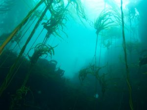
Today, these underwater parks showcase a wide variety of the state’s natural treasures, and they’re not limited to marine areas; the underwater portion of Emerald Bay State Park in Lake Tahoe includes an underwater “trail” where divers can explore several sunken recreational boats from the early 20th century. There are over twenty of these underwater parks in California, from the kelp forests of Southern California’s Crystal Cove to the geologic formations in the mountain lake of D.L. Bliss State Park. Read a list of these underwater parks here.
The kelp forests of Crystal Cove
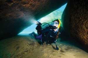
A diver swims between two rocks in Lake Tahoe
So what does it mean for an area to be designated an Underwater Park? The goals of the program are to protect and conserve marine ecosystems, educate visitors on the ecology and history of the underwater and intertidal area, and provide nearshore recreational opportunities.
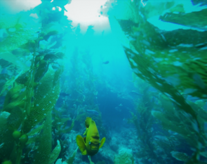
The Fort Ross Underwater Park includes the marine areas around Fort Ross Cove, Sandy Cove Beach, and Clam Beach. The cove is protected from strong winds and waves, so much that the Russian settlers once built and launched ships there—so it’s a perfect place for divers to enter the water and explore the vibrant marine environment. The ocean here is teeming with life, from sea lions to sea palm kelp.
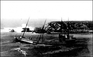
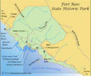 The Underwater Park is also home to the wreckage of the SS Pomona, a 225-foot passenger and freight carrying steamer which ran aground in Fort Ross Cove in 1905. You can see scientific diver John Herrald explore this historic wreck in this footage, or even go and see it for yourself!
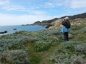
If you’re not much for diving, there’s still plenty to see in the underwater park. Bring a pair of binoculars or just a sharp eye and you can spot birds like black oystercatchers on the rocky shore or cormorants flying over the surf—if you look out further over the ocean, you might even catch a glimpse of a humpback whale! For those who want to get their feet (and hands!) wet, the intertidal zone in Fort Ross Cove and Sandy Cove is dotted with tide pools, home to charismatic critters like sea anemones, crabs, isopods, and more.
If you’re looking to take home dinner, licensed fishers can cast out a line from the beach, rocky coast, or kayak and catch rockfish, cabezon, or rock bass.
For those interested in getting involved with the conservation of Fort Ross’s underwater park, Fort Ross Conservancy offers a variety of coastal stewardship surveys that monitor the populations of harbor seals, sea lions, and other marine life. Students of all ages are welcome to take part in our Marine Ecology Program (MEP), which offers hands-on education in marine mammal observation and the importance of biodiversity and conservation. We also offer guided tours for individuals and groups where you can use our spotting scopes as our experts show what lives just offshore—Stellar sea lions, migrating birds, and more!
All of this and more is hiding just beneath the surface of our ocean. Come join us!
-- Zez Wyatt, Special Correspondent
Foraging: Making the Best of an Invasive Species
Along the ridgeline where Fort Ross State Historic Park abuts Seaview road (or Meyers Grade road, depending on the section), plants are flourishing in the peak of summer blossom and seed. Some are native and others are non-native, and while we may forget to stop and consider their origins, many of these offer exceptional wildcrafting (foraging) opportunities.
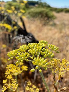
The most ubiquitous of these is wild fennel (Foeniculum vulgare). Native to the Mediterranean, fennel owes its success in naturalizing throughout most of the temperate world to the fact that fennel spreads by both root and seed. Fennel (like many invasive species) loves disturbed areas such as roadsides, pastures, abandoned lots, and bodies of water both fresh and brackish. In fact, the next road trip you take, scan the sides of the road. Fennel can be found along roadsides throughout the U.S. And while collecting on California State Park property is prohibited, fennel abounds! You can find it just about everywhere.
It seems the exact history of how it made its way is unclear, but it has been in California for over one hundred and twenty years and according to the California Invasive Plants Council, “is presumed to have escaped from cultivation repeatedly (Robbins et al. 1941)” Fennel seeds were often scattered on the floors by Spanish missionaries to give off their pleasant herbal aroma. Without a doubt, some of those seeds escaped to become happy little invasive plants.
Fennel grows with such enthusiasm that it often overcrowds, outcompetes, and limits reestablishment of native species. Once established, fennel is incredibly hard to remove. It is herbaceous, meaning it dies back every winter, but don’t be fooled, it’s just waiting for the spring sun to come back from its base. Manual methods of removal are most effective when individual plants and stands are new. Digging them out by hand (necessary as they spread by root too) is recommended over bulldozing or tilling as this can further spread the plant. Grazing can be effective too, but the tall and tough mature plants tend not to tempt our four-legged friends like cows, sheep and goats. Perhaps more satisfying than hard manual labor to remove the plant, is to wild forage its useful parts for your kitchen, generously topping the plant will at least slow its spread.
Although fennel definitely poses an invasive problem, it’s also a wonderful perennial herb with great culinary and medicinal properties. In fact, all parts of the plant are edible. The flowers themselves can be eaten as a delightful garnish to any salad.
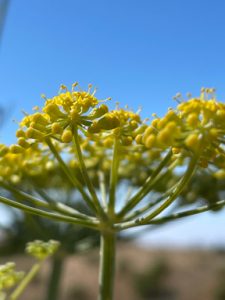
Fennel pollen has become popular as a health food supplement and gustatory culinary delight. While collection of the pollen can be quite laborious, a little goes a long way. For a quick how-to, Honest-Foods guides, “You collect fresh fennel pollen by going to each flower head and shaking it into a bag, dislodging the pollen, which will be a lovely, creamy yellow. Incidentally, this works with either garden or wild fennel.”
.jpeg) Fennel pollen has become popular as a health food supplement and gustatory culinary delight. While collection of the pollen can be quite laborious, a little goes a long way. For a quick how-to, Honest-Foods guides, “You collect fresh fennel pollen by going to each flower head and shaking it into a bag, dislodging the pollen, which will be a lovely, creamy yellow. Incidentally, this works with either garden or wild fennel.”
Fennel pollen has become popular as a health food supplement and gustatory culinary delight. While collection of the pollen can be quite laborious, a little goes a long way. For a quick how-to, Honest-Foods guides, “You collect fresh fennel pollen by going to each flower head and shaking it into a bag, dislodging the pollen, which will be a lovely, creamy yellow. Incidentally, this works with either garden or wild fennel.”
The seeds on the other hand are easy to collect and wonderful--considered by some even better than their cultivated counterparts. You can harvest the seeds at any age - young, green and tender, or fully mature. They have a wonderful smell - like licorice and anise and a flavor of the two combined. Hank Shaw of Honest Foods recommends sprinkling them on ice cream, an inventive treat that’s surely worth a try!
Medicinally, fennel is well known for its digestive aid properties, helping relieve heartburn, gas, and bloat. A tea of steeped seeds and flowers is delicious. Open any herbalist's book and you’ll see pages of accolades, singing the praises of our invasive friend with so many ways to heal.
Beyond their culinary and health benefits, their lovely yellow umbel flowers also attract beneficial insects and the ripe seeds are a favorite food source to many warbler species.
So, the next time you set your sights on removing your local patch of fennel, make sure to collect some of those delicious seeds before you do.
The more we learn about the species we live near, the more we might discover we have a veritable spice rack in our own backyard!
--Song Hunter, DL Programs Manager
Camino del Presidia de Rose: Old Maps & Fort Ross - Bodega Route
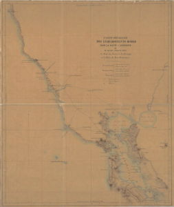
The modern layout of the roads in Sonoma county follows the contours of the old Native American trails used by the indigenous people of California for centuries before the arrival of the Russian-American Company (RAC) settlers to Bodega Bay in 1809. RAC newcomers used the intricate Native American knowledge of the land to first survey their new environment, and later to expand their possessions in Northern California. By the time Russians left the coast in 1841, a complex system of roads was established. The roads connected different parts of the Russian domains but all led to Bodega Bay (Port Rumyantsev) where the Company had its trading harbor at which goods and supplies were assembled before being shipped off to the Russian colonies in Alaska.
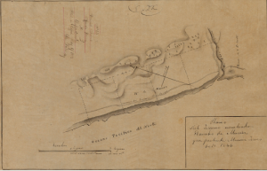
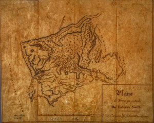
The basic road configuration that existed during the Russian Californian adventure was first outlined in the map by the French explorer Eugène Duflot de Mofras. The chart shows three Russian ranches - Kostromitinov, Khlebnikov, and Chernykh being connected between Fort Ross and the main Russian port by a series of roads.
Following the departure of Russians from Sonoma, the Mexican government divided the Russian possessions into different land grants - Rancho German and Muniz Rancho were allocated to the North of the Russian (Slovyanka) River, while Russian farmlands around the main RAC harbor became Estero Americano and Rancho Bodega. The maps of these land grants also show the Russian-made roads.
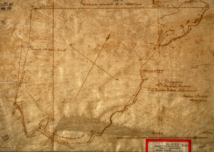
The main difference between de Mofras map of Russian possessions and the early Mexican hand drawn maps, especially of Muniz Ranch made three years after the Russian departure by Jean Jacques Vioget, is the presence of the coastal route that is not depicted by the Swiss cartographer, who also happened to be the witness to the transfer of Russian property to his fellow countryman Captain John Sutter.
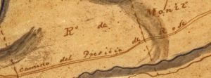
This seacoast route, ‘'Camino del Presidia de Rose'’ was the auxiliary trail connecting settlers of Ross with the rest of the Russian establishments south of the fortress.
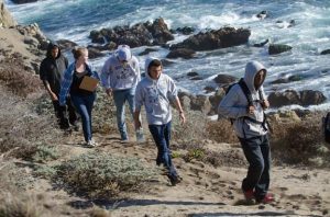
This coastal trail, used by the Native Americans since time immemorial, was utilized by members of a large fur hunting brigade, the so-called Bonaventura Brigade led by John Work and Michel Laframbois who passed by Fort Ross in April 1833. The group, consisting of 163 people, was reluctantly permitted to pass by Fort Ross by Manager Petr Kostromitinov and was only allowed to camp five miles up the coast from the Russian settlement out of fear of contracting malaria. Security matters were also part of the concerns. Here is how Mr. Work described that encounter:On 18 April 1833 amid “stormy cold weather” the party “proceeded over a succession of hills 15 miles westerly to the seashore and along the shore to the Russian River, which we crossed immediately, and encamped,” Work wrote in his diary. “Here we met the governor of the Russian establishment [Petr Kostromitinov] he objected to our passing his establishment and said there was no road except right past the fort…” (Recognizing Indian Folk History as Real History: A Fort Ross Example, by Glenn J. Farris, American Indian Quarterly , Autumn, 1989, Vol. 13, No. 4, pp. 471-480)“We told him that we meant [?] to pass but that we meant to pass it at a distance, he was told that our two nations were at peace and that we did not see any reasons for his objections and that we must pass. He then said that as there was no other way he would allow us to pass [words obliterated] to accompany him [words obliterated] it was after dark when we arrived....”
The next day, the large party, Work wrote, “passed the fort past noon and proceeded 5 miles farther on, where we encamped, the governor and a number of his people accompanied us to the encampment, he invited me to dinner with him at the fort in the evening.” The next day the Brigade departed heading north along the rugged Sonoma coast into Mendocino.
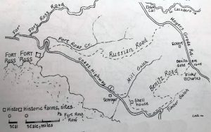
Apparently, the coastal route between Bodega and Fort Rort was considered quite dangerous, especially for cargo to travel on. Most of the goods delivered between the fortress and the main port took place by water. Those who traveled overland preferred to gallop on the main road from the Northeastern gate of the fort over the ridge where Meyer grade road now is and down to the Slavyanka (Russian) River. After crossing the Russian River either by boat or simply on horseback during low water levels the Russians further proceeded down to Bodega (Rumyantsev) Harbor. (Note the Benitz Road and Benitz Gate on the map, named for the Benitz family who ran the Fort Ross ranch before G.W. Call took it over.)
Thanks to these old maps, we can now trace back the history of some of the early Californian transportation routes that were used by the Native Americans and later by the Russians to transport goods between different points of the domain.
-- Igor Polishchuk, Director of External Relations
Beachwatch is Recruiting Surveyors!
Become a Sanctuary volunteer and ocean steward of our coast.
Greater Farallones Association and NOAA's Greater Farallones National Marine Sanctuary are seeking community scientists to help collect data on the condition of sanctuary shores in North-central California. Beach Watch volunteers monitor assigned beach segments and collect data to support conservation and management of our sanctuary’s wildlife, habitats, and ecosystem.
It is a top goal of our programs to reflect the demographics of the greater Bay Area. People of all backgrounds and life experience are welcome and encouraged to apply. Learn more at https://farallones.org/beach-watch/
You’ll find four Beach Watch volunteers in the Fort Ross Conservancy staff. We love the BW community and strongly believe in the work we do with Greater Farallones Association and NOAA's Greater Farallones National Marine Sanctuary. Check it out today!
No Campfires Allowed at Salt Point Campgrounds
Due to dry and extreme fire conditions, all devices fired by wood or charcoal as well as open flame lighting such as “tiki torches” are prohibited at Salt Point State Park, Navarro River Redwoods, Hendy Woods, Willow Creek and Pomo Environmental Campgrounds. The ban is in effect until December 31st -- or until it's canceled because of RAIN and improving conditions! You can still sleep under the stars and cook on a camp stove, but please be mindful of the dangerous fire conditions. Thank you for helping us keep these lands safe!
Visit Fort Ross and Salt Point - Book a Private Tour Today!
It’s a great time to visit Western Sonoma coast - the hills are still green, the wildflowers persist, and while this season can be a bit windy, we are seeing migrating humpbacks and plenty of marine mammals. FRC offers private and group tours at both Fort Ross and Salt Point. Both of these locations are rich in human stories and natural history, and starting your visit with a private or group tour can help you more deeply understand the landscape and history. The Fort Ross museum and bookshop are open seven days a week.