MARCH 2019 ENEWS
.jpg)
Dear friends of Salt Point and Fort Ross,
If you follow us on social media--Instagram or Facebook--you’ve seen Song Hunter’s glorious and occasionally dramatic photos showing just how awash the Sonoma Coast is in springtime rains and abundant wildflowers. It’s been a wet one! Our community suffered devastating flooding along the Russian River this last month and our hearts go out to all those who are doing the backbreaking work of cleaning out from under the mud. Fort Ross’ location high atop the marine terrace fared better and we suffered only a few leaky roofs, downed trees, and the occasional power outage.
Rain or shine, later this week I’ll be out in the field with Sacramento’s Cultural Resources Division Chief Leslie Hartzell and a talented team tasked with designing the Fort Ross Cultural Trail. This trail will create a new and much-needed ADA-compliant footpath traveling up coast from the Visitor Center and looping back to the windmill; the trail then heads south on Old Highway One to Sandy Cove and then onward to the newly restored historic cemetery. Along the trail our visitors will encounter new interpretation using cutting edge technologies to tell the stories that aren’t properly told through the existing buildings. The goal is to give voice to the long legacy of the Kashia, as well as the Alaska Native, Ranch, and promyshlenniki (self employed and contract) Russians who lived outside the historic Fort Ross compound. We are incredibly excited to be a part of this new Fort Ross / Metini project and look forward to sharing substantive updates as the new path manifests.
It’s officially Spring season and Fort Ross is now open seven days a week. Thanks to hardworking California State Parks staff, Salt Point campgrounds at Gerstle and the lower loop at Woodside will open on April 1st. With wildflowers and migrating whales a nearly everyday occurrence now is a great time to visit--or if you need more incentive, check out our Events page. In this newsletter, FRC staff share their enthusiasm with articles on recent sightings of Ross River Otters, Mercedes Call’s room with a view, observations on Old Highway One, and worldly insights from one of our shopgirls in a new segment called Notes From Behind the Counter.
If you support our work and you’re not already a member, please do consider joining Fort Ross Conservancy. We love what we do, and we want to know that you are with us.
Wishing you an inspiring Spring season,
Sarah
Mercedes Call’s Room With a View
 The year is marching on! The seasons are changing and wherever you look you can see signs of winter turning to spring at Fort Ross State Historic Park: blufftops bursting with the colorful display and biodiversity of wildflowers; bushy blows of migrating Pacific gray whales heading north to the cold Arctic waters of their summer feeding grounds; and seabirds, such as the resident pelagic cormorant, sporting their eye-catching breeding plumage. While the land of Fort Ross may be continually shaped by mighty forces of nature and the landscape redrawn and reimagined by varying human influences, it’s intriguing to think how these enduring signs of spring have remained year after year — on display for any and all who might take the time to take it in.
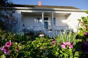
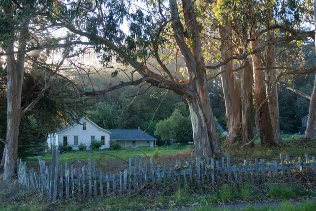
 The land of Fort Ross has been witness to a unique collage of human cultures and individual characters. It’s incredible to think of all the different people who have lived and worked here, and to wonder which people from our past might have stopped to appreciate nature’s seasonal spectacles. One person that springs to mind is wife and mother, Mercedes Leiva Call (1850-1933). In 1873, decades after the Russian American Company closed up shop and left their beloved settlement behind, The Call family — headed up by George Washington Call — purchased 2,500 acres of Fort Ross land. By 1878 the Calls had built a family residence here. This house which we now refer to as the “Call House” served as a place where George could manage his thriving shipping and ranching businesses, and where Mercedes could entertain visitors and raise their children — six girls and three boys! This house, a remnant of Fort Ross’ Ranch Era history, still stands to this day.
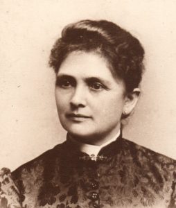

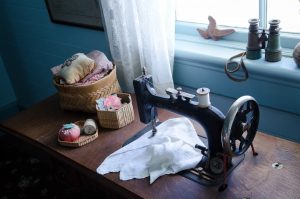
Mercedes, a Chilean-born orphan, loved nature and flowers. She was an avid gardener and some of the flowers she planted in her garden continue to grow and paint the Fort Ross landscape we see today. We also know Mercedes enjoyed sewing and she worked hard at it — making the clothes and quilts for her large family. The Call House faces the ocean, and one of the first things you see when entering the front door is a large window — extravagant for this time period — facing the porch and presenting a spectacular view. From this vantage point you can see beyond the front porch, far along the blufftops and out into the great Pacific Ocean. It is at this window that Mercedes placed her sewing station. From here she could work away at her motherly tasks while taking in the beauty of Fort Ross.
Throughout its modern human history, Fort Ross State Historic Park has been a home, a source of livelihood and a place to recreate for thousands. All the people who have spent time here, whether it be for a few hours or their entire lives, have been connected by the elements of nature that have existed here for millions of years. This spring join the thousands who have come before and see our Park’s natural and historic beauty and richness for yourself! And don’t forget to stop in to the Call House to explore this well-loved slice of Ranch Era history, and see what Mercedes Call saw from her perch by the window.
The Call House is open the first weekend of every month by docent-led tour, from 1-4 P.M. Don’t miss our next open days on April 6th & 7th!
Ranch Era Book Recommendations: The Old Salt Point Township and The Old Salt Point Township II: Ranch Era Settlers by local author, historian and Call House Volunteer Manager Lynn Hay Rudy. Pick up your copy at the Fort Ross Visitor Center Bookshop!
Read more about the Call House and watch the 22 minute video!
—Charon Vilnai, Programs Instructor, Sea Lion Survey Project Lead, and Call House Guide
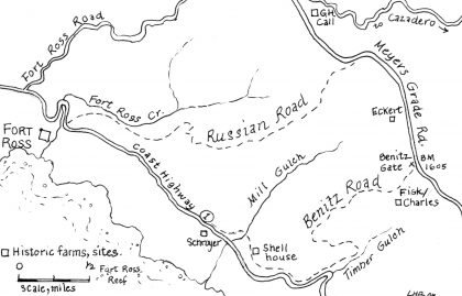
Highway One at Fort Ross
 The road to Fort Ross is not an easy one. In fact, the road to Fort Ross, especially a paved road, is still a relatively recent phenomenon. Our coast’s dynamic rugged terrain dictates, even now.
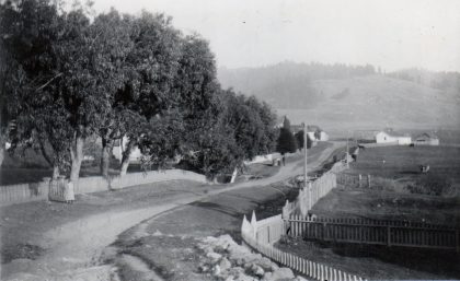
Early on, during the dominant pre-European period, a labyrinth of Kashaya Pomo foot trails, likely originally following game trails, wove their way through the redwoods and across the bluffs, between the ocean, ridges and inland valleys. Then, with the arrival of Russians and Alaska Natives, the coastal ocean transport of ships, small and larger kayaks were key. Next, during the Ranch Era, shipping continued and a network of backwood horse and mule train trails, wagon and logging roads, stagecoaches, bridges and ferries… eventually leading to adjacent railroad lines… were developed through the years. It wasn’t until the late 1880s when the first initial north-south “through road” was created up on the ridge (now known as Seaview and Meyers Grade Roads) and an initial coastal road was opened. But the Jenner cliffs are formidable, and the cliffside route didn’t open more-or-less permanently until 1925, and only by the 1940s private cars and trucks dominated coastal transport.
California State Route 1 now stretches almost 700 miles, making it the longest state route in California. The SR 1 designation was first assigned in 1939. This segment of Highway One, one of the last segments to be completed, is officially designated as “Coast Highway One.”
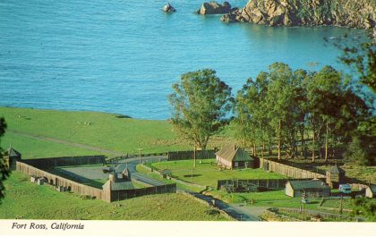
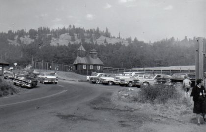
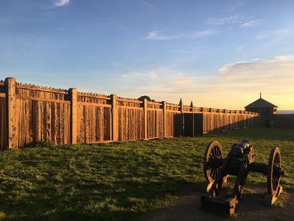
Here at Metini-Fort Ross, the early Kashaya Pomo trails and then, during the Russian Era, the old Russian trail (from the northeast corner area of the fort) to the ridgetop, was replaced by the coastal road which eventually led right through the fort to the coastal terrace, as the fort walls had fallen during the Ranch Era. Many an oldtimer visitor still remember visiting Fort Ross and parking either inside or just outside the remaining fort walls. As visitation and traffic increased on the then new Highway One, so did the impact on the remaining old fort buildings. In 1970 the chapel (reconstructed after the 1906 earthquake) burned down. A year later, in 1971, the Rotchev House roof burned.
This was the beginning of a new era for Fort Ross. CalTrans rerouted Highway One in 1971-1972, creating the current route (notice the sharp turn in the new road near the chapel). Following the rerouting of the highway, the reconstruction of the fort walls, buildings and new water supply system began in earnest. The Officer’s Quarters was rebuilt by 1983, the Kuskov House by 1984, and Visitor Center by 1985. Only in 1996 was the park residence removed from behind the fort in 1996. Recently, just before the Fort Ross bicentennial, the Magasin was rebuilt in 2011 and, adjacent to the parking lot, the most recent reconstruction of our windmill.
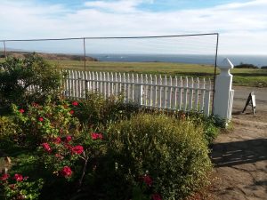
Remnants of old Highway One are still seen as one walks northwest along the ocean terrace from the Fort Compound, past the Call Ranch House, and, following the old dotted line, up the hill. At the top of the hill, the old highway continues straight ahead, to the overflow parking, dumpsters and into the cowfields, whereas the new park road turns sharply to the right, past the windmill and to the parking lot and Visitor Center. Currently a new Cultural Heritage Trail is being planned for the northwest cape, featuring the Kashaya Pomo story. Part of this trail, the loop return, will use old Highway One.
—Hank Birnbaum, Bilingual Guide, Historical Specialist & ELP Instructor
-from The Old Salt Point Township, a wonderful, highly recommended encyclopedic local history of our coast, written by Lynn Hay Rudy, and available for purchase in the Fort Ross bookshop.
“...Some of the Indian trails were known and used by the first European settlers. But others were strictly their own: A woman who grew up at Plantation 85 years ago remembers that the Pomo women working at the hotel there walked several miles home, barefoot, not along the white man’s wagon road, but along trails “near the river, which only they know”. These were secret paths, which we could not presume to map…
Settlers’ Roads
It was but a few years from Indian trails to Euro-American wagon roads. Salt Point Township, still today a relatively undeveloped and isolated section of the county, is lucky to have kept traces of many of it’s old trails and roads. Although they can be irritatingly vague, the old 19th century maps are a great resource for determining the routes of the first trials and roads - and their changes. And roads did change: a grade that worked for a horse or mule might be too steep and narrow for a heavily loaded wagon, its curves too tight for a four horse team.
Sometimes neighbors would get together and build their own wagon trails between their farms…
...The course of the early coast road was set by the locals for their own needs, and besides running up creeks for logging access, nearly always went through a farmer's barnyard, not around it. Today we treasure our quiet and privacy and build roads to keep traffic away; these isolated settlers looked forward to travelers, most of whom were their neighbors…
About 1923, the state began buying up rights-of-way, and resurveying, to begin a proper Shoreline Highway. Then, as now, the most difficult section was the five mile cliff stretch over High Point which G.W. Call had pushed through fifty years before. Oscar Charles, one of Call's sons-in-law, and a county supervisor at the time, strongly opposed the cliff route as unsafe, unstable and difficult to repair. (He was right, as we have seen.) Ock Charles refused to sell his right of way over the cliffs, and the county had to condemn it. Charles used the money to buy his wife, Mary, a piano.
The road was built, of course. Font Richardson of Stewarts Point did the engineering and the tractor work; his brother A.H. kept the books. First called state highway 56, it was a narrow, dangerous road, not well marked, and has indeed proved difficult to keep repaired. There were seven gates to open along the cliff section they were replaced by cattle guards in the 1940s when the road was finally paved. By that time it had become Highway 1. For decades the five miles of cliff-hanging road between Fort Ross and Russian Gulch suffered from serious mudslides every winter, forcing the traffic over the old Ridge Road. In the last few years, after widening, marking and heavy rebuilding, it now seems quite stable, although it continues to terrify quite a few visiting tourists. But what views!...”
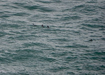
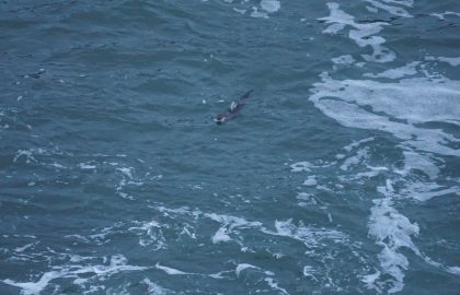
It's an Otter!
It’s an otter! A Northern river otter (Lontra canadensis) that is. To spot the infamous sea otter (Enhydra lutris) who, for all intents and purposes, is locally extinct or extirpated, would be newsworthy! All thirteen otter species are related, in that they belong to the subfamily Lutrinae and are mammals in the weasel family.
River otters are nimble, playful, thick-pelted carnivores. They are much smaller than their ocean-dwelling cousins the sea otter, weighing from eleven to thirty pounds. The sea otter, in contrast, can weigh from thirty to one hundred pounds!
We appear to have a family group of otters recreating at Fort Ross…but do they live here? Over the last three months, I’ve observed them three times. Once as the group of four and two sightings of solitary otters during early morning and dusk, proving they are crepuscular--most active at twilight--critters. If you’re hoping to spot one, these times are your best bet.
River otters stay in burrows or upcycle abandoned dens in either fresh or saltwater climates such as estuaries, along river banks, in swamps, or even rocky coastal shorelines. The burrows are usually intricate networks of tunnels with many openings, with at least one terminating in the closest water source. The otter’s range varies greatly, from one and a half miles to nearly 50 miles! With that kind of range, they could easily be traveling north from the Russian River, or they could be true locals with a modest home in the banks of Fort Ross creek.
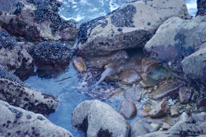
As predators with a wide and varied taste for both land and sea fare, river otters are known to prey upon the most accessible and abundant food sources. I’ve seen them foraging in the tidepools at Sandy Cove collecting crabs, mussels, and other tasty morsels found in our rich intertidal zone.
They do not migrate annually, but will leave their home if their habitat is depleted of foods, or becomes ‘unclean.’ River otters are sensitive and quite susceptible to the effects of environmental pollution, so while we know we have a terrible imbalance in our subtidal and intertidal habitats with urchin barrens, kelp loss, and abalone starvation, at least we know our shores are not polluted because they meet the high standards of river otter cleanliness!
Our local (Sonoma & Mendocino) river otter population must be on the upswing because as I write this on March 14th, 2019, Jeanne Jackson, author of the excellent book and blog Mendonoma Sightings, just posted about a river otter spotting. Last year our resident marine ecology expert Jackie Sones from the Bodega Bay Marine Lab and author of the exquisite blog The Natural History of Bodega Head wrote about her river otter sightings in July, October and again in November, to name only a few occasions!
While river otters have a plush 160,000 hairs per square inch, sea otters have a luxurious 600,000 to one million hairs per square inch! This density and softness of fur was the main reason our local sea otter population was hunted near to extinction, and probably what saved the river otters from a similar fate. Sea otters were traded by the Russian American Company with the Chinese for tea, metal tools, and other goods. In just 170 years, nearly a million sea otters were killed by Russian, English, and American hunters. According to the Fort Ross Conservancy Sea Otter webpage, “In 1911 a treaty between Russia, the United States, Japan, and Great Britain was made to protect sea otters and Northern Fur Seals (combined, these were the two most prized North Pacific fur-bearing marine mammal species hunted very competitively in the early 19th century by Russia, America, Britain and others).”
While we have yet to see the return of our majestic sea otter population as far north as Fort Ross, I am thrilled to know these oceans still hold an abundance of foods, clean waters, and safe and undisturbed waters for these beautiful creatures, the river otter. One could hope that this is a foreshadowing of the return of their cousin, the sea otter. .
Song Hunter, Director of Programs
Notes From Behind the Counter
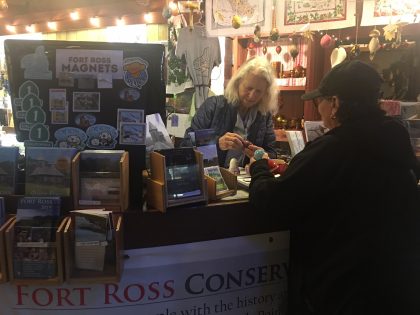
As on a wheel, we picture the “hub” of anything as being at the center. A web of transport systems in a city, often called a hub, allows for movement in every direction, dispersing and collecting concentrations of people and goods from trains, buses, taxis and trucks, a pulsing center of activity, a hubbub, so to speak.
Lately, my days working at Fort Ross have felt similarly active and far-reaching. Though floor space is limited in the Visitor Center, I walk many metaphorical miles with our guests as they describe far distant home towns and countries of origin. What began for me as a curiosity has become a hobby I practice concurrently with my occupation as greeter, guide, interpreter, and sales person, to name just a few of the hats this position requires. In the course of introducing newcomers, or refreshing return visitors to the sights and locations of the park’s features, I often ask about their travels and where they call “home” these days.
During a week in February, for instance, we had groups or individuals from these places beyond the U.S.: Russia, Germany, Switzerland, Belgium, Holland, Sweden, France, Spain, India, Australia, Costa Rica, Ukraine, and Poland. And at least these many states were represented: Massachusetts, Texas, New York, Arizona, Washington, Alaska, Oregon, Ohio, Pennsylvania, Vermont, Utah, Connecticut, Nevada, Colorado, and Florida.
Within California we had visitors from Pico Rivera, Modesto, Calistoga, Huntington Beach, Berkeley, Kingsberg, Sacramento, Lodi, Petaluma, Fort Tejon, Temecula, Yosemite, Long Beach, Los Angeles, and Cazadero. Every month brings a new array of place names and a diversity of people with, I dare to say, at least these common traits: curiosity, adventuresomeness, respect, and civility.
Just as the original Settlement Ross had drawn together a variety of ethnicities and nationalities, it still does. In the early 1800s Russian America Company ships brought Finns, Germans, Russians, Siberians, and others of European descent, and an Alaska Native labor force to complement the local Native Californians who had been living in this region for untold generations. Following California statehood in 1850, during the Ranch Era, the site was transformed into yet another hub for a growing community. Refurbished structures were dedicated as dance hall and post office, the coves were ports for shipping locally-produced goods to and from San Francisco, and roads were upgraded for wagons. Eventually narrow-gauge railroads reached Cazadero from the South and stagecoaches continued the journey of city visitors to their coastal destination.
Whether a history buff, retired or current educator, photographer, birder, bibliophile, sightseer, or wandering vacationer who has either stumbled onto or made a beeline to Fort Ross, a majority of our visitors are usually surprised at what they find and what is offered. Most responses include a deep appreciation and even an inquisitive excitement, accompanied by exclamations about the beauty in which they have discovered an unsuspected, very interesting history. Visitors/Guests? are eager to share their impressions and often have more questions, so we get to talking.
Inevitably, I must turn to other tasks and they need to be on their way. Reluctantly I surrender them to their meanderings but I am left feeling that in a few minutes, though we have just met, we listened, told stories, and shared an obvious caring about history, each other, and our surroundings. Although residents and purposes have evolved since its inception, Fort Ross is every bit the worldly hub it ever has been.
Lake Perry, Administrative Assistant
Fort Ross Photo Contest
 Calling all amateur photographers!
Fort Ross Conservancy is holding a photo contest leading up to our July 27th, 2019 Fort Ross Festival.
We will award three winners. Each winner will receive free entrance to Fort Ross Festival and -- if the winner is over 21 -- two free beers from our Beer Garden! We will print and display the three winning photographs during Fort Ross Festival for all to enjoy and appreciate.